
NEW YORK — In a historic move that reshapes how the world sees the African continent, the United Nations General Assembly has overwhelmingly voted to replace the centuries-old Mercator projection with a map that accurately reflects the true size of global landmasses.
The resolution, titled “Correct the Map,” passed with 164 votes in favor, six abstentions, and only a single vote against, cast by the United States.
Led by Togo and strongly backed by the African Union, this non-binding resolution encourages governments, educational institutions, and digital tech platforms to abandon the 1569 Mercator projection in favor of the “Equal Earth” map developed in 2018.
At ABT News, where we constantly monitor the intersection of international politics, emerging markets, and African corporate governance, this is more than a geographical update—it is a monumental shift in the global narrative.
The Cartographic Illusion
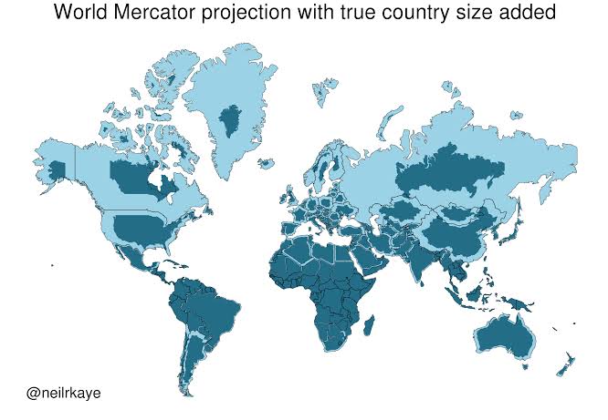
For centuries, the Mercator projection has dominated classrooms, newsrooms, and boardrooms. Originally designed by Flemish cartographer Gerardus Mercator to help European sailors navigate the seas, the map preserves the shapes of landmasses but violently distorts their relative sizes.
The distortion bloats regions closer to the poles while shrinking landmasses near the equator. The most glaring victim of this mathematical compromise is Africa.
- The Greenland Illusion: On a standard Mercator map, Greenland appears roughly the same size as Africa.
- The Reality: Africa is actually about 14 times larger than Greenland.
- The Scale: You could fit the United States, China, India, Japan, Mexico, and much of Europe inside the African continent—with land left over.
“A Fair World Begins with a Fair Map”
Togolese Foreign Minister Robert Dussey, the driving force behind the resolution, made it clear that cartography is deeply political.
“A map is never neutral. It shapes perceptions, influences how the place of peoples and continents in the world is understood… A fair world begins with a fair map.” — Robert Dussey
African advocacy groups, including Africa No Filter, argue that visually shrinking the continent has historically diminished the perception of Africa’s vast natural resources, population size, and immense investment potential. Correcting this visual footprint aligns directly with the modern push for equitable economic partnerships and international respect.
France, a co-sponsor of the resolution, announced immediately that its foreign ministry would abandon the Mercator map, with Foreign Minister Jean-Noël Barrot calling the correction an “act of truth.”
The Lone Dissent
The United States stood alone in opposing the resolution. U.S. Representative Yaryna Ferencevych sharply criticized the initiative on the assembly floor, arguing that the UN was suffering a loss of credibility by debating 16th-century map projections rather than focusing on “genuine problems of international peace, prosperity, or good relations.”
What Happens Next?
While the UN resolution does not legally force technology companies or global publishers to change their platforms overnight, it sets a powerful new global standard. The endorsement of the Equal Earth projection provides a mandate for digital publishers, media houses, and educational boards to update their visual assets. Togo has already committed to replacing all of its school geography materials by the end of the year.
For digital journalism and global business strategy, the implications are clear: the way we visualize the global market is changing. Africa is no longer accepting a minimized space on the world stage—or the world map.


 By
By